


Today on R&D World
AI agents with $3,000 budget flunk open-ended AI research assignment

OpenAI debuts ChatGPT for Academic Researchers program will offer complimentary access to 100,000
Presenting the 2026 R&D 100 Finalists

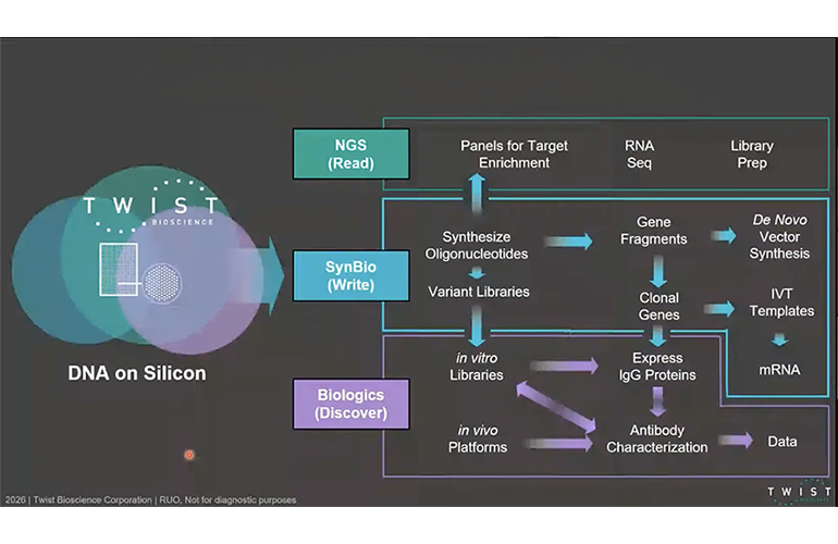
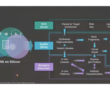
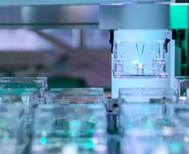
As AI floods drug discovery with designs, Twist uses DNA chips to tackle the wet-lab bottleneck
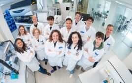
Inside AutoLabs: PNNL’s self-correcting AI still needs an expert in the loop
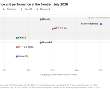
Claude Opus 5 outscores Fable 5 on 8 of 13 benchmarks at half the token price
R&D 100 announcement schedule is released for 2026

As U.S. power demand surges, Brookhaven taps AWS in aim to drive 20-100x faster power grid decision-making with GridSearch AI
Judging panel announced for 2026 R&D 100 awards program
SwRI and SMU join push to engineer solid-state battery interfaces

UC San Diego engineers found a short-cut to higher-energy recycled EV batteries

The difference between using GenAI and working alongside it
Recursion says its Norstella-backed real-time simulation can expand trial eligibility by up to 40%

How EcoBOT’s automated plant lab knows where it’s guessing
Physics See More >
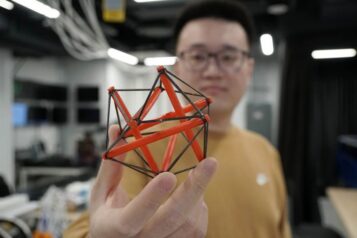
Princeton researchers uncover hidden mathematical link between origami and structural design
Designing irregular structures often means wrestling with huge systems of equations. Princeton engineers have found a shortcut, using a mathematical bridge between origami and tensegrity to preserve known mechanical properties as a structure shifts into a more complex shape. Tensegrity is a structural principle where a continuous network of tension (cables or strings) and a…

NTT Research taps Tetsuomi Sogawa to lead PHI Lab as optical-computing work advances

IBM physicist and Montreal computer scientist share Turing Award for quantum information breakthroughs

Research team shows nanoparticles adhere to quantum mechanics

Researchers could be one step closer to understanding the origin of matter thanks to a new study
Sponsored Content See More >
Operational discipline is a critical determinant of clinical utility for neurologic monoclonal antibodies
By Bill Holt, DO, Vice President, Neuroscience Therapeutic Area, ICON For neurologic monoclonal antibodies (mAbs), the scientific hurdle is no longer the primary barrier to success. Increasingly, operational execution—not efficacy—determines whether these therapies reach patients at scale. From multiple sclerosis (MS) to neuromyelitis optica spectrum disorder (NMOSD) to early Alzheimer’s disease, mAbs have moved from…


Life Science See More >
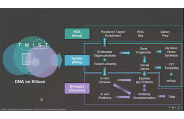
As AI floods drug discovery with designs, Twist uses DNA chips to tackle the wet-lab bottleneck
Whatever your take on the current AI wave, it is clear that the prospect of creating software has been transformed. “The most impressive edge of it is probably using [genAI models] to help speed code development. And that’s kind of working,” said the computer scientist Jaron Lanier recently. Frontier AI labs are now pushing for…

Recursion says its Norstella-backed real-time simulation can expand trial eligibility by up to 40%

NIH employees warn of ‘institutionalized destruction’ one year after Bethesda Declaration
Cradle’s CEO on the AI agent boom and the reality of experimental feedback in life sciences

Inside BD’s plan to forecast hospital drug demand with AI while keeping models within bounds
Nanotechnology See More >
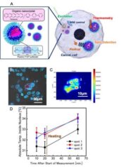
Researchers developed quantum nanosensors that can measure the temperature of a single cell
Researchers have developed molecular quantum nanosensors (MoQNs) designed to operate in the cytoplasm and nuclei of living cancer cells to map radical-generation processes and thermal dynamics that are linked to cancer-associated cellular physiology. The sensors use molecular-level uniformity to achieve a threefold enhancement in spectral resolution and superior thermometric specificity. The platform enables absolute temperature…


Energy See More >
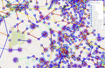
As U.S. power demand surges, Brookhaven taps AWS in aim to drive 20-100x faster power grid decision-making with GridSearch AI
Brookhaven National Laboratory says its GridSearch AI system could cut grid simulations from months to minutes as DOE targets 20–100× faster grid decision-making. Speaking at the recent Genesis Mission Annual Summit, an event dedicated to the U.S. government’s AI-focused initiative that aims to double the productivity and impact of American research and innovation within a…


Chemistry See More >

Elkem Silicones rebrands as Bluestar Silicones after ownership change
The specialty materials maker Elkem Silicones has rebranded as Bluestar Silicones, reviving a name the business used from 2007 to 2017. The change follows the April 30 close of Bluestar’s acquisition of the majority of Elkem’s silicones division. The company says manufacturing sites, production processes, raw materials, product names and commercial trademarks all stay the same,…

Martian chemistry: how the Curiosity rover detected organic compounds on Mars
Sandia scientists develop rapid PFAS test using desorption electrospray ionization
MXenes, the family of 2D transition metal carbides, get a clean surface, and a 160-fold conductivity jump
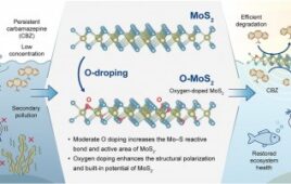
A dual-energy catalyst breaks down drug pollution where conventional treatments fail
Material Science See More >
Researchers develop sawdust-based foam as polystyrene bans force industry to adapt
At least 11 states have enacted bans on expanded polystyrene (EPS), which is commonly used in packing peanuts and food packaging, due to environmental harm. The food packaging industry is now looking for compliant alternatives. However, these tend to be more expensive than conventional polystyrene. Researchers have created a sustainable alternative to polystyrene using sawdust…

Researchers develop compostable PLA that potentially could be used for biomedical applications

Elkem Silicones rebrands as Bluestar Silicones after ownership change
How Atomis is using AI simulations to commercialize MOFs

Sandia turns to lightweight AI to speed up ceramic inspections for nuclear weapons components
Semiconductors See More >

SK Telecom puts SK hynix fabs into an NVIDIA Omniverse twin, following Samsung and TSMC
SK Telecom said on June 1 that it has put SK hynix’s semiconductor fabs into a digital twin built on NVIDIA Omniverse libraries, with commercialization to follow in stages under SK hynix’s “Autonomous Fab 2030” roadmap. SK hynix’s news is part of a trend involving Omniverse-based fab twins. SK hynix and SKT first surfaced the…

What Apple’s new CEO could mean for its R&D strategy

Copper is hitting its physical limit with AI. Why NTT thinks photonics is could unblock it.

Nanoscale ridges in a substrate add 15 K and 50 Tesla to a superconductor’s limits
Marktech expands large-area silicon photodiode portfolio for spectroscopy, medical diagnostics
Aerospace See More >

No storms, no forecast: NASA’s DAPHNE mission targets quiet-time space weather
Disturbances on Earth, from thunderstorms to earthquakes, send ripples into the upper atmosphere, disturbing the region that low-Earth-orbit satellites fly through and that GPS and communications signals must cross. “Think of waves as throwing a pebble into a body of water, and you see those waves propagate out in a circle. That’s what happens in…